


Dynamic Data Capture and Visualization for Invasive Species Trends Analysis
Fei Tian College and Northern Academy, Middletown, NY USA – A World Bridge® Project
Collaborative Model for Acquiring Current Data and Visualization on the NASA WebWorldWind Geospatial Platform – A World Bridge – Trillium Learning
This combined A World Bridge team is a collaboration of students from two academic institutions, Fei Tian College and the Northern Academy prep school. The application is designed for acquisition of current farm data from the UN FAO, and Visualization on the NASA WebWorldWind Geospatial Platform.
Goal
The NAA A World Bridge team believes that sharing and comparing known information about a problem is essential to fundamentally solving the issue – in this case, being able to protect crops against invasive species. Our application development provides an easily accessible and convenient-to-use digital application that can be utilized by farmers and farming communities alike who are facing the same challenges.
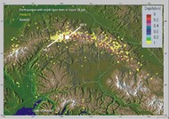
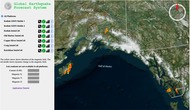
This project consists of a web application using NASA’s WebWorldWind geospatial platform that displays Fall Army Worm (FAW) activity in different areas of the world using place marks and a heat map with colored outbreak zones. The development of this application began only 4 weeks ago and is a prototype; it uses NASA’s WebWorldWind geospatial platform to display a place mark layer and separate heat map layer indicating FAW populations. The application can be used throughout Africa and other continents by small-holder farmers, helping them to protect their food and livelihoods.
The current prototype is under development on the Chrome browser, so please use that application to run the program.
From the FAO initiative: “Fall Armyworm (FAW) (Spodoptera frugiperda), is an insect pest of more than 80 plant species, causing damage to economically important cultivated cereals such as maize, rice, sorghum, and also to vegetable crops and cotton. The insect pest is native to tropical and subtropical regions of the Americas. In the African continent, it was first detected in Central and Western Africa in early 2016. By early 2018, only 10 out of the 54 African states and territories had not reported infestations by the invasive pest. Maize is now the most infested crop in Africa. As a staple crop, it is unlikely that farmers and their families will want to abandon maize.
FAO and its partners have been at the forefront of tackling FAW and continue to support prevention, early warning, and effective response. An integral part of FAO’s sustainable management program for FAW in Africa is the FAW Monitoring and Early Warning System (FAMEWS) mobile app. Data from the app provides valuable insights on how the insect populations change over time with ecology, to improve knowledge of its behavior in Africa and guide best management.”
Before you run the application, Please watch the Evaluaton Video (see below), which demonstrates how to use the app, and will show you as much functionality as possible within the 3-minute timeframe.
(Click this link or the picture below to play the video. The video will stream after a pause while beginning to download, and you’ll have the option to expand to the window size, You may also downoad the video.
The Application
The UN FAO Heatmaps application is a completely open source application based on NASA-ESA WebWorldWind. Programming code utilized a variety of tools and applications, including Javascript, HTML5, CSS, Python, and server-side programming – all available on the GitHub site.
Critical FAW infestation site data is provided by the UN FAO. The student-developed application presents the information available for farming communities worldwide in a 3D visual geospatial environment. This application provides data about each major FAW site and allows the user to navigate in a geospatial environment while being available for all farming communities worldwide.
A reminder, the current prototype is under development on the Chrome browser, so please use that application to run the program.
Click HERE to run the application
UN FAO Invasive Species Heat Maps Source Code
The application’s source code may be accessed on GitHub HERE
Educational Outreach
The geospatial platform is designed to help farmers around the world who are struggling to protect their crops against fall army worm invasions. These pests are not only responsible for the loss of irreplaceable crops and profits, they also pose a serious threat to the world, who relies heavily on large plantations as its primary source of food. It is therefore undeniably important to raise awareness and exchange data about different regions in order to take effective action against the invading fall army worms.
Features Overview
UN Heatmap Data Workflow
The data workflow for this project is illustrated in the graphic below. The process consists of:
1. Initial data collection and information analysis from submitted user record forms
2. Verification and latitude-longitude processing for each record location
3. Output data and/or error to data container
4. Server-side data storage and WebWorldWind layer foundation
5. Data visualization of WWW on the application, GUI functionality and client calls.
Evaluation Video Documentation – Slides from the Evaluation Video
The Evaluation video above may also be viewed as a PDF file for your review.. This slide set provides a tutorial-level view of the many features, data and documentation available in the UN FAO Heatmap application, and demonstrates many details of the level of information, sophisticaton of the application, and UN data available to help manage a community’s resources.
Click on the title tezt above, or the picture to the left to view and/or download the PDF document.
Server-Side and Technical Documentation/Description
Click HERE to view a separate page on the UN FAO Heatmap technical documentation.
Click HERE to see functional workflow for how a user’s actions are performed within the software.
Meet the Team
Mentor: Professor Ron Fortunato
Assistant Mentor: Mr. Anson Zhao
A World Bridge® collaborative team members include Trueman Wu, Julia L. Zhu, Amy Yin, Huaqi Zhang, Minghui Zhang, Zedong Ding, Albert Sun, Charlie Cai and Annie Sun from Fei Tian College and Northern Academy, Middletown, New York, USA.